
Geosciences:
Delivering deeper insight
and solutions for offshore projects
Geoscience expertise
At Global Maritime, we deliver fully integrated geoscience solutions across offshore wind, energy, subsea cables, and transmission. By uniting geophysics, engineering geology, subsea cable expertise, geomatics, and geotechnical engineering, we provide deeper insight, faster decision‑making, and stronger, more resilient designs.
From shoreline to water depths beyond 3,000 metres, we support clients through the entire project lifecycle – from early feasibility assessments to final installation, our geoscientists are present at every step of the project.
Integrated geoscience support for offshore development:
Field Concept Studies
We conduct early-phase feasibility assessments that bring together geotechnical, geological, geophysical, and GIS inputs. These studies help define layout strategies, construction methods, and engineering viability.
Survey Design and Support
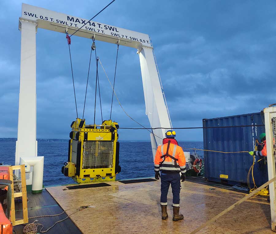
Global Maritime provides full cycle survey support, from survey strategy and scope definition through to procurement, management and QA/QC of all deliverables.
Using our SMP and OPSIM platforms alongside experienced Offshore Client Representatives, we ensure safe, high‑quality geophysical and geotechnical survey execution and fully validated datasets that feed seamlessly into ground models, foundation design and cable engineering.
Ground Modelling and GIR
We develop detailed ground models that integrate geophysical, geotechnical and geological data to clearly define subsurface conditions and engineering geological units.
Using advanced 2D and 3D UHRS interpretation and in‑house integration tools, we assess geology and geohazards, refine site stratigraphy, and produce Geotechnical Interpretative Reports (GIRs) that provide the design‑ready parameters needed for reliable foundation, cable and site‑wide engineering.
Bottom Fixed Structures
We deliver comprehensive expertise in bottom‑fixed foundation structures, supporting the full lifecycle from optioneering evaluation to design, installation and decommissioning studies across all major foundation types tailored to site‑specific soil conditions.
Anchoring Design and Studies
We deliver geotechnical-led anchoring solutions, supported by integrated geosciences. Our expertise spans renewables, aquaculture, and oil & gas – ensuring safe, efficient seabed interaction.
Geophysics
From survey design to full site characterisation. Our geophysical team interprets high-resolution seabed and subsurface data to characterise shallow geology, identify geohazards and turn complex data into insight.
Owner’s Engineering and Advisory
We act as an extension to your team – providing independent oversight across all geoscience disciplines – ensuring quality, compliance, and value throughout the project lifecycle.
Subsea Cable Route Design and Engineering
Through the full cable design project lifecycle, from concept, through FEED to detailed EPCI design and into operations, we provide all engineering services for the protection and installation of export, inter-array and interconnector cables with focus on risk reduction. Our team addresses route complexity, soil variability, and emerging threats – including sabotage resilience.
Jack-up
We deliver comprehensive Jack‑up assessments to ensure safe and reliable operations across all seabed conditions. Using our in‑house JUGGA software, we evaluate site conditions, perform leg‑penetration analyses, and identify geotechnical and geohazard risks.
Our site‑specific studies and zonation workflows provide clear, data‑driven guidance for confident deployment. In addition, we apply advanced numerical modelling—using Finite Element Method (FEM) and Material Point Method (MPM) techniques—to tackle complex soil–structure interaction challenges, including boulder and quay‑wall interaction, gravel‑pad optimisation, and rapid penetration (RPD) risk mitigation.
Integrated expertise, smarter outcomes
Our strength lies in uniting disciplines. By integrating expertise across all geoscience specialisms, we build robust ground models, enable smarter cable and route engineering, and support efficient anchoring and foundation design.
This integrated approach is powered by our in‑house software tools—more than just software, they are project enablers that streamline delivery, enhance data transparency, and solve real‑world challenges.
Trusted throughout the project lifecycle, our tools are shared with clients as part of our deliverables, ensuring seamless communication, coordinated decision‑making, and efficient project execution.
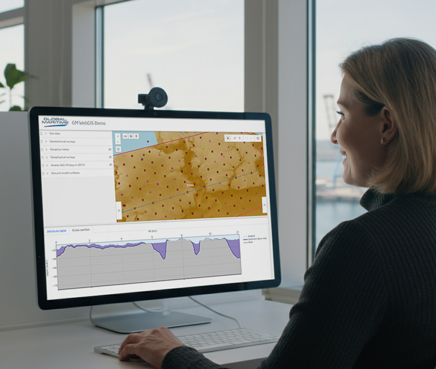
WebGIS
Built for collaboration. Our WebGIS platform provides an intuitive, browser‑based environment for visualising and interrogating project data in real time.
Built on open‑source technology and accessible to all project stakeholders, it brings together ground model results, CBRA outputs and other key datasets in a single, interactive interface. With customisable layers, 3D voxel visualisation and on‑the‑fly model interrogation, WebGIS enhances data transparency, supports faster decision‑making, and ensures teams always work from the latest, curated project information.
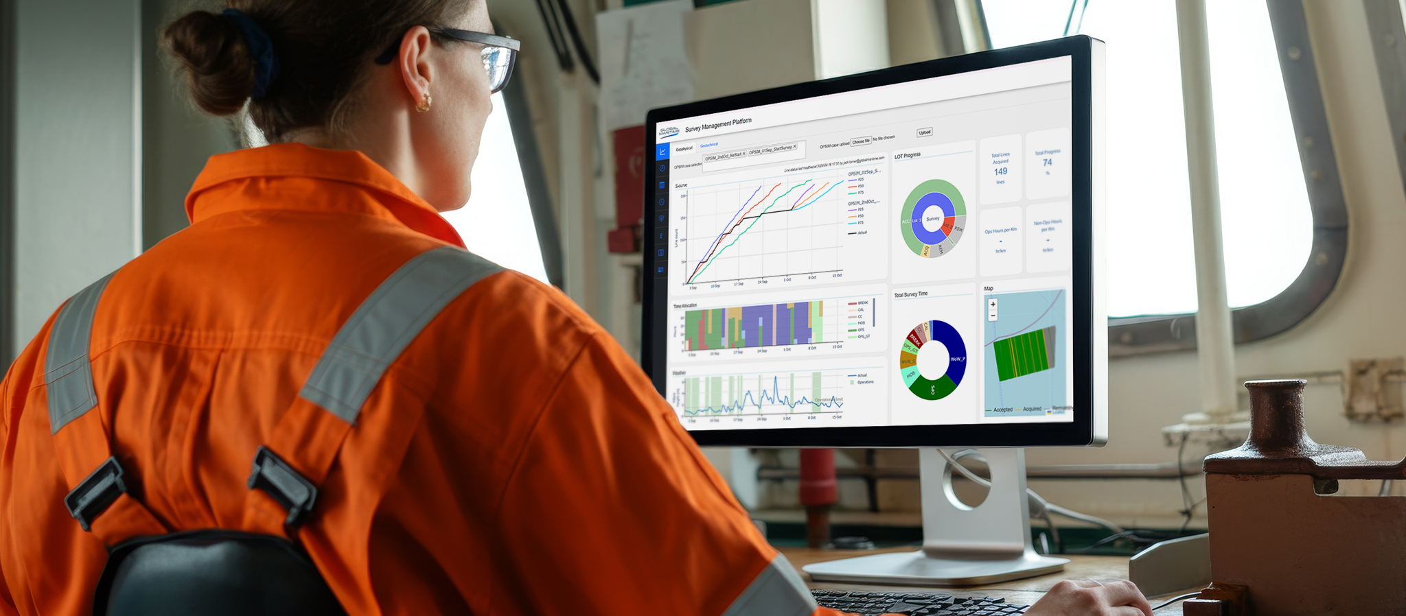
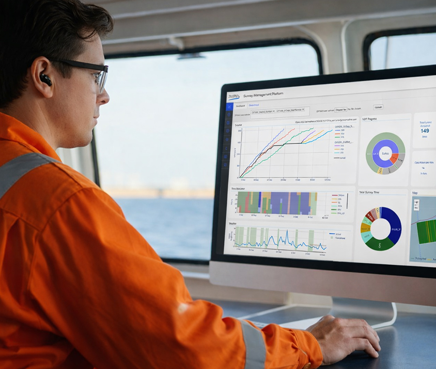
Survey Management Platform (SMP)
Global Maritime’s Survey Management Platform (SMP) is a browser‑based dashboard that streamlines the planning, tracking and delivery of offshore surveys. It brings together progress, cost, HSE, weather and operational data into one intuitive interface, giving project teams instant visibility and control.
Powered by our OPSIM weather‑forecasting engine and tailored to each project, SMP improves communication across all stakeholders, enhances decision‑making, and helps keep surveys on schedule and within budget.
Our key disciplines within
Geosciences include:
Geophysics
From survey design to full site characterisation. Our geophysical team interprets high-resolution seabed and subsurface data to characterise shallow geology, identify geohazards and turn complex data into insight.
Geotechnical Engineering
Grounded in precision. Our Geotechnical Engineering team evaluates soil conditions, derives design parameters and performs detailed foundation analyses to ensure safe, efficient and optimised solutions for offshore wind turbines, substations and subsea infrastructure.
Engineering Geology
Ground thruth for offshore desing. Our Engineering Geology team evaluates shallow geology, geohazards and seabed risks, integrating geophysical and geotechnical data to build clear, engineering‑ready ground models that support safe site development, foundation design and effective offshore risk mitigation.
Geomatics
Spatial data integration and delivery. Our Geomatics team manages, analyses and visualises spatial and survey data—combining geodesy, data standards, 3D modelling and seabed constraint mapping—to support accurate routing, risk assessment and integrated decision‑making across offshore wind projects.
Subsea Cables
Our Subsea Cables team delivers end‑to‑end cable engineering—from route planning and constraints mapping to CBRA, burial assessment, trenching analysis and landfall design—ensuring safe, buildable and cost‑efficient export and inter‑array cable systems for offshore wind projects.
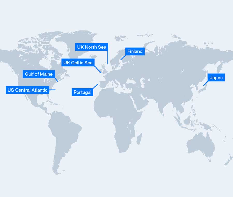
Seabed Intelligence Report (SIR)
Our Seabed Intelligence Reports integrate geology, geohazard and geotechnical analysis, mapping, and risk assessment to support offshore wind developers in early-phase site evaluation, designed to accelerate decision-making and reduce uncertainty during the leasing and concept development stages.
The SIRs cover over 134,000 km² of potential lease areas worldwide, including, Portugal, UK North Sea, Celtic Sea, Irish Sea, Finland, Japan and the Gulf of Maine.
To purchase a report or explore how our insights can help advance your project, contact our team.
Highlight
Projects
Get in touch.
Contact our team to discuss your next project. Our experts are ready to support safe, efficient project execution – no matter where you are in the world.
Our services for your sector
Our expert team provides five specialized service lines – each designed to deliver expert support, technical assurance, and operational excellence across offshore industries.
